Logie Coldstone
This page reviews the history of Logie Coldstone where our own Esson family line lived for over three hundred years and provides a time line of some events extending to Cromar and beyond.
Clicking the Google map below leads to OS maps on streetmaps.co.uk, while a large and extremely interesting set of historical maps can be found at the National Library of Scotland site including this OS map from around 1874 covering a good part of Logie Coldstone.
Logie Coldstone in Aberdeenshire
Logie Coldstone and Cromar
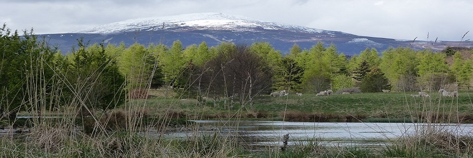
Logie Coldstone lies on Deeside, about thirty five miles inland from Aberdeen in the Howe of Cromar, Cromar being a basin of land a few miles across surrounded by hills, most notably, Morven to the West, with Pressendye and Craiglich to the North and East. The small area is made up of fertile agricultural land, forest, lochs, burns and rough ground
The church parish of Logie Coldstone was created in 1618, when two separate parishes, Logie-Mar and Coldstone were brought together. It ceased to exist when it became part of Cromar parish in 1984, although the name is still commonly used for the area and sometimes for the small village of Newkirk itself.
The name Logie derived from the Gaelic word lagan which means a hollow, or low lying land. The old parish name added to this the suffix Mar to make it Logie-Mar.
The first documented reference to Coldstone parish seems to have been in 1275 AD in The Old Taxatio taxation records. It was recorded then as Col-essan (meaning corner of much water), but over the years was also recorded in many different forms, the final one for the Parish as such being Colquholdstone, at the time it was merged with others. It has also been suggested the current name might come from the more similar sounding col-struan (corner of many streams). The church of the parish itself, St Neachtan’s, stood next to the road which climbs up towards Strathdon on Kirkhill where Coldstone graveyard still exists alongside a nearby ancient stone slab with cross.
As regards ownership of Coldstone, an early charter was given by the Bishop of Saint Andrews to Lord Forbes of Kinaldie on 5th November 1439. Numerous charters followed, showing the Forbes kept possession until a complicated series of transactions and court cases between 1692 and 1695. As a result of those, first William Farquharson, then his brother John Farquharson of Invercauld acquired the bulk of the lands. The Farquharsons of Invercauld owned Millhead and many of the other farms occupied by Essons, as evidenced by copies of leases and other documents which date into the 1800’s.
The map and link below gives an idea of church parish boundaries, helpful when considering history and old family records.
Map of Parishes in the North East Counties of Aberdeen, Banff, Kincardine, Moray and Nairn
The map below shows some of the places Esson families lived in the past. Finding these in the 1696 List of Pollable People For Tax Purposes in Aberdeenshire (Volume 1) helps to understand even older parish boundaries which were still being referenced. Names of landowners, including the Forbes, the Gordon’s, and the Lairds of Logie, Drum, and Skeen can also be seen in that book.
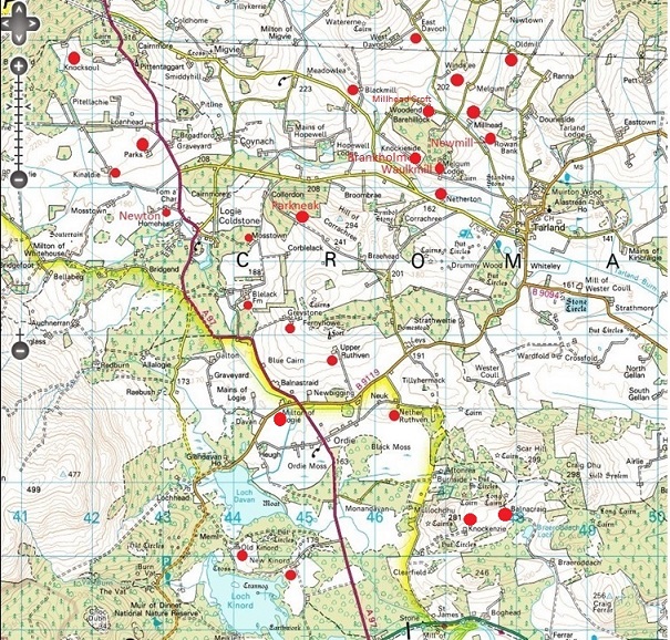
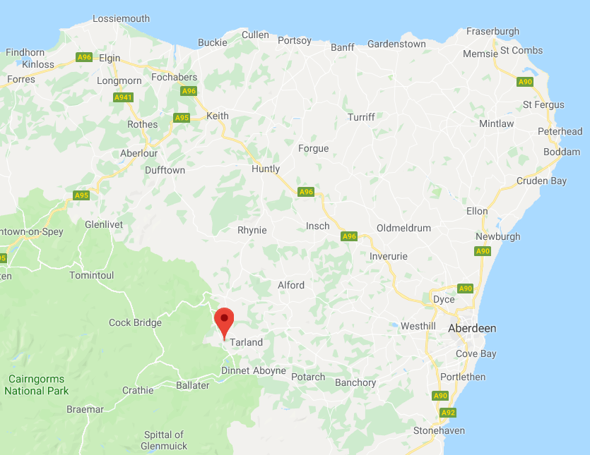
Logie Coldstone today with some past Esson homes marked
The Records of Invercauld 1547 to 1828 (edited by J.G.Michie 1901) holds much information on historical land ownership for Logie Coldstone including the parishes and the Baronies of Melgum and Kinaldie. It also refers to notable landowners in the area including the Forbes, Gordons, and the Farquharsons and their origin and progress as a clan.
Place names of West Aberdeenshire by James Macdonald, and Celtic Place Names in Aberdeenshire by John Milne discuss the origins of place names, many of which are derived from gaelic obviously..
_____________________
Some General History and a Timeline of some events
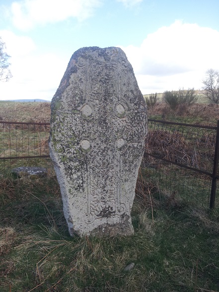
Pictish Cross of around 700 AD on Loch Kinnord’s bank
The glaciers of the last Ice Age left Deeside around 12,000 years ago. As they did so they shaped and revealed many features of the landscape we see today, including the melt water channel of the Burn O’ Vat and the great “kettle holes” formed by stranded ice that ultimately became Loch Kinord and Loch Davan. At that time, the area was connected directly to the European land mass, and game and other animals would have started to migrate here in search of grazing as the climate warmed sharply. With them came groups of people, the hunter gatherers of the Mesolithic.
About 24 miles East of Logie Coldstone at Warren Field, on Crathes Castle Estate, a “lunar calendar” thought to be around 10,000 years old has been identified. This consists of a series of pits designed to hold posts aligned with the cycles of the moon and sun. It is thought to have been been used to predict seasonal changes, a critical activity for people whose survival depended on migration, hunting and foraging,. If the assumptions on time and purpose are correct, (although that is under discussion), this pre-dates known “lunar calendars” elsewhere in the world by around 5,000 years.
In 2012 Reading University carried out an excavation at Waulkmill, close to Millhead and Tarland. The document linked describes the excavation, which uncovered remains from Neolithic (4,000 to 3,500 BC), Bronze Age (ca. 2,500 BC) and Roman Iron Age times.
The Waulkmill excavation was carried out near the site of an old stone circle, of which only one of the 12 or so original stones remains. There were many stone circles in the area, and many signs remain, for example at Doune Hill and Knowhead, with the most striking, albeit restored site being at Tomnaverie, near Tarland. This dates from around 2,500 B.C and again was thought to be aligned with lunar cycles. Tomnaverie is an example of a recumbent stone circle, a type of circle found far more often in Aberdeenshire than elsewhere. Like others of its kind it has a massive flat stone laid on its side, level, wedged between two upright stones in a way which frames the moon at its point of lunar standstill a phenomenon which occurs every 18.6 years. Tomnaverie’s recumbent stone and two uprights also frame Lochnagar in the most impressive way, and Morven and Mount Keen are to either side so it is easy to see why the site, a hillock raised overlooking the area below for miles around might have been chosen for its purpose. Scattered quartz crystals at this site suggest they were used in rituals here.
As mentioned above, the Waukmill excavation revealed Roman remains. These includes burial artefacts, jewellery and game pieces. It is increasingly being realised how extensive the Roman presence was. Roman encampments are more common and often larger than once thought. A site at Inverurie is now thought to have been the size of 60 football pitches.
Throughout its history the wealth of the land of this place and the ferocity of its people meant that strategic places, including access routes had to be protected by fortification. Many iron age sites are evident, and in Mediaeval times substantial castles dominated the scenery.

Map from The Making of the Scottish Rural Landscape by David Turnock. Routledge. Copyright.
To the South of Deeside lay high exposed and boggy moorland called mounth. Through this only a limited number of passes offered sensible access to the country to the North. From Deeside, the routes made their way North, again following a small number of viable routes. Capel Mounth, Fir Mount Munth Keen Road all arrived, (or left) Deeside to the south of Cromar, while important routes North went North of Davan, past Towie to Strathdon or North via Tarland.
These strategic places were protected by significant castles in Mediaeval times, as were any sites which offered military advantage. Another name for this area besides Logie Mar was Logie Ruthven, where Ruthven meant fort. There was no shortage of them here. Kinord had a castle on its largest island and a tollbooth or prison on a neigbouring island. On Davan, surrounded by a sophisticated set of moats and sluices was the Ha’ of Logie Ruthven mentioned in Wyness’s account of the battle of Culblean. Migvie castle, now almost invisible, was once an important seat of government for the Earls of Mar. There are suggestions a fort existed below the now flattened church of Coldstone which stood on the side f another shallow loch, now drained. Farther afield was Coil Castle belonging to the Durwards, Lumphanan’s Peel Castle of the Lundin’s, Aboyne, Craigevar, Kindrochit and Kildrummy to name a handful. The map to the left shows strategic routes through Deeside and sites of castles in Aberdeenshire.
Judging by the fortifications and military activity visible it was also an area which seemed worth defending and fighting over. In part this all explains why the area has such a rich history and archaeological record. Despite appearances today, Deeside as a whole and Cromar itself have been far from quiet and unchanging places through the centuries.
In The History of Loch Kinnord John Michie describes an extraordinary history of settlement around Loch Kinord, Loch Davan and Culblean. This includes Neolithic remains and an extensive Iron age settlement near the two lochs, with fortifications, artefacts and a crannog.
The History of Logie Coldstone and Braes of Cromar by the Reverend John Michie and Tales and Memories of Cromar and Canada. by Donald Farquharson are both old books but they give a very good view of the history of Logie Coldstone and an idea of how earlier times must have been.
Some Dates and Events
A timeline of events of general interest and family history in the area.
1296 and 1303
Edward I, the infamous “Hammer of the Scots” camped twice with a large army at or near Loch Kinord when he came to plunder and suppress the area.
1335
The Battle of Culblean was fought near the loch head of Davan on St Andrews day, 30th November 1335. The second link below gives an old detailed account. Andrew de Moray is said to have used the Hall of Logie Rothwayne on Davan as a head quarters before the battle the battle, while some of the defeated English forces were said to have taken refuge at Sir Robert Menzies’ castle on Kinord. The Red burn
Wikipaedia – Battle of Culblean
The Campaign and Battle of Culblean by W. Douglas Simpson
1504
In 1504 James IV visited Kinord Castle in a journey which was reputedly based on a bet on how little expense (for him) he could travel for. Payments to the castle, owned by Gordon, Marquess of Huntly were recorded in detail.
1597
In common with many places in Scotland, England and across Europe at that time, witch trials were held in Logie Coldstone and Lumphanan. Witch trials were a phenomenon which lasted three hundred years in Europe with loss, some say, of 40,000 lives. At the turn of the 16th century James I and VI of Scotland and England was adamant about the risk, publishing his book “Daemonologie” in 1599. He demanded witch hunts and trials were carried out and in 1597 John Gordon, 2nd laird of Blelack was obliged to convene a trial, while a group of Parish elders sat in judgement at the Kirk of Coldstone.
1637 to 1647
In 1637 and the years that followed, chaos reigned over matters of religion and the interference of the Charles I in church and state. These years proved very difficult for people in Cromar, primarily as a result of plundering and oppression by opposing armies and what were often little more than bandits. On top of conflict over religious matters, Presbyterian versus Catholic and government versus Royalist, enmities between clans and families played a large part in the problem. The conflicts, loyalties and enmities had far reaching effect.
In 1638 a National Covenant was created and signed, in an effort to bring together those resisting changes being imposed by Charles I. By the end of May 1638, the only areas of Scotland where the Covenant had not been widely accepted were the remote western highlands and the counties of Aberdeen and Banff, where resistance to it was led by the royalist George Gordon, Marquis of Huntley who opposed the government aligned Covenanters. Montrose, initially with the Covenanters turned to join the Royalists in time.
Cromar was plundered seven times in one year by the two opposing armies who advanced and retreated as seemed expedient. At one point a Covenanter army of over 2000 men camped outside Tarland just days after the Royalists had left. Crops, goods and livestock were taken, people and animals were ransomed. In the absence of any form of law and order at times, the local people, including those who lived in Logie Coldstone and around were looted by bandits.
Opposing armies moved back and forth through Deeside during the conflict, demanding provisions for their upkeep, billeting men and levying fines as they saw fit.
Eventually in 1647 the highland Royalists and the catterans or bandits were defeated and compensation courts were set up to make some amends for damages done during the period. One such court was convened at Tarland where William Reid of Newmill as an elder of the Parish, with others, had to vouch for claims made for reparation. He signed his statement as follows:-
“We, Wm. Reid, in Newmiln, elder, in Tarlen, and John Durvard, elder, in Coull, with our hands at the pen led be the nottar underwritten at our handis, because we cannot vreat ourselffis“
An Outline of Scottish Covenanter History in the 17th Century
Covenanter Compensation Court in Tarland
The National Covenant and civil war
1638
Leaving aside the time of the Covenanters, much of the 17th and early 18th century were lawless times, and cattle thieves and raiders were common. They often became involved with armies in bigger conflicts and at times those gave ordinary people a respite as the bandits went off to fight too. One notorious outlaw was Gilderoy, thought to be Patrick McGregor, a leader of a notorious group of bandits, or limmers as they were known. He is famed in legend for hiding out in the Burn of Vat cave. There is a small cave, still named Gilderoy’s cave, where he is supposed to have hidden behind the small waterfall. The whole valley and the almost enclosed Vat cave itself offered some concealment though, and would clearly have been easy to defend. He and his band were not romantic people to the locals who were often terrorised or had their property stolen. Ironically it seems he was originally encouraged to contain lawlessness in the area by the Marquess of Huntly, but became as bad if not worse than the worst of the bandits. He and his men were renowned once for burning down many farms in the area on the day when people were away at a wedding. He was eventually caught and hanged in 1638 at Edinburgh. Even after Gilderoy was gone, his band continued to cause trouble for some time, until they were also caught.
1666
In December 1666 Robert Fforbes of the Miln of Melgum, a short distance from Millhead was indicted at Edinburgh for going into Tarland one night, heavily armed with sword and dirk to the house of John Ross and wounding him several times and injuring the man’s hand to the extent he lost use of his finger. It was said this was when John Ross grabbed Robert Fforbes sword in self defence. The case was tried in June the year after, and the accused found guilty not of mutilation in the end (which carried the death penalty), but of wounding for which he went free after paying £40 in compensation to the victim, with what sounds like a degree of relief. After the indictment being recorded in December 1666 the trial itself and detailed debate is recorded in “The Records of the processings of the Justiciary Court, Edinburgh, 1661-1678 – page 218 which hopefully remains at the link below.
Robert Fforbes trial in Edinburgh
1688, 1689, 1715 and 1745 The Glorious Revolution and Jacobite Rebellions
Described here – Jacobite Rebellions.
The 1690’s : Scotland as a whole
Scotland’s economy suffered badly in the 1690’s, Background factors included intense competition with England, protectionist French trade policies, legal limitations on its shipping and a down turn in its cattle trade. Foreign wars had also taken their toll, and now two other events added to the problems.
The Seven ill years
In the 1690’s countries across Europe experienced what is thought to have been the coldest weather in 750 year based on one study of tree rings. Scotland was hit hard, with successive years of crop failures in what became known as the Seven ill years. Contemporary accounts described hellish conditions, with break down of social structures in places. Around 5 to 10% of the people of Scotland are estimated to have died due to the conditions. It is thought Aberdeenshire may have lost as many as 25% of its population in places.
The Darien Scheme
In the latter part of the 1690’s another disaster affected Scotland as a whole. Struggling to cope with difficult trading conditions and the effects of famine The Scottish Parliament took steps to try and improve matters. The Bank of Scotland was founded, and the Company of Scotland was set with authority to raise public funds to promote trade with Asia and Africa. The Company of Scotland initiated a project to create a settlement in the Isthmus of Darien, the Isthmus of Darien as it is known today, and from there to establish an overland pathway connecting the Atlantic to Pacific, thus securing and efficient trade route with Asia and Africa. On paper this seemed a sensible idea. The settlement was just 150 miles from the Panama canal today, the isthmus only 50 miles across and the Spanish had been using the route to transport Peruvian gold for a long time before. The exercise to raise capital from all levels in society was more than successful. Around 20% of the free wealth of Scotland from all levels in society was poured into the scheme. The scheme was notably opposed by Spain, England and the powerful East India Company, who all saw a risk of competition. Scotland was alone in the venture.
Depopulation
Aside from fatalities, these disastrous circumstances led to widespread emigration from Scotland at this time. Between 1650 and 1700 approximately 7,000 Scots migrated to America, 10-20,000 to Europe and England and 60-100,000 to Ireland. Emigration to Ireland, particularly to Ulster, was a continuation of a process that had been underway since the early seventeenth century, with population of cheap and abandoned land in the north created by James VII’s invasions in the early 1690s. It has been estimated that 20,000 Scots emigrated to Ulster between the famine years 1696 and 1698.
Cromar must have been affected directly by the events of this decade, and perhaps even more so by their longer term consequences.
1696
William III of England, II of Scotland set out to raise money to help fund the army and navy and to pay for recent foreign wars through the 1696 Poll Tax in Scotland. Unsurprisingly given the times, it was an unpopular move and frequently unpaid. Today family researchers have at least the benefit of the two volume, meticulously documented List of Pollable Persons in Aberdeenshire 1696.
1693 : Closer to home : Transfer of the lands of Coldstone, Melgum and Kinaldie to the Farquharsons
The 1696 list of Pollable Persons indicates the Farquharson’s of Invercauld owned four fifths of Coldstone Parish/ The lists divided the parish into three “townships”, Coldstone, Kinaldie and Melgum.
The Forbes had been the owners from around 1493 when charters show they were gifted with the land by the church. This persisted until 1693 when the land seemed to fall into the ownership of a Hary Elphinstone due to a lack of continuity in the Forbes line and marriage between the two families. A series of bonds had been taken out on the land however, perhaps reflecting the poor financial circumstances of the estate, and William Farquharson was able to show his ownership of the land through a difficult court action. William died shortly after taking possession in 1694, and John Farquharson if Invercauld took possession not long before the 1696 list was produced.
Our earliest known Esson ancestors therefore lived on lands in Coldstone owned first by the Forbes and then the Farquharsons.
1707 Acts of Union
Driven by a number of factors including Scotland’s dire economic position and the wish of many in England to avoid a catholic Stuart king in Scotland the Acts of Union were passed, bring Scotland and England together to form the United Kingdom of Great Britain.
1715 Jacobite Rebellion, Lord Mar’s Revolt.
1741
John Farquharson of Invercauld convened a meeting with the landowners of “the five parishes”, (Coldstone, Logie, Migvie, Tarland, and Coull) along with Aboyne, Glentannar and Birse.
Bandits had been harassing the people of Deeside, stealing cattle and goods and demanding protection money. Many of the outlaws were remnants of the Jacobite army from the 1715 rising, dispossessed of land and employment, with only the skills of soldiers and vagabonds.When the 1745 rising and call to arms came the law abiding people of the area breathed a sigh of relief to see the backs of the outlaws as they went to fight once more.
1745/1746 The ’45 Jacobite Rebellion and Culloden
1745
Around 1745 just before Gordon of Blelack set off to join the rebellion he asked John Farquharson, an acquaintance and a noted “wizard” who is said to have lived at the Parks of Coldstone (some say he was at Carue or Nether Ruthven) to get rid of some fairies who lived in the Seelie Howe at Carue farm (on Carue Hillock). They were a nuisance to Gordon it seems. How? who knows ? maybe they just upset superstitious workmen. “Seelie”, supposedly from an ancient word meaning happy or lucky was a word used to refer to fairies. There are a number of burial cairns in the area, and what appears to be a souterrain where stone cups were said to have been found at a higher point, near Ferny Howe above Upper Ruthven, where there is also an unfinished fort. Perhaps the belief in fairies came from attempts to explain ancient remains and some unfortunate events in the area.
Anyway the story is well known. John Farquharson persuaded them to go the Hill of Fare which they didn’t like, and as a result they cursed the Gordons and the Farquharsons. The curses in verse are also well known.
If nothing else this shows the level of superstition in those times, a world before most of the advances of science and medicine we take for granted today. Fairy hills, seelie courts and wichts are commonly described in Scotland and the rest of Britain. Unusual patches or grass, rings of fungi, and especially tumuli and inexplicable remains were things people attributed to fairies, who were as in this case, best left alone, in case they turned nasty. Maybe someone had a reason for spreading a rumour of angry supernatural creatures. Someone made the verses up, and it was not fairies. Gordon of Blelack hid out at a number of houses after Culloden, one at least where his presence was explained to servants as a haunting of ghosts. Maybe the fairies helped explain another hiding place.
John Farqhuarson, the wizard, may well have been related to the Essons by marriage. The writer of Reminiscences of Cromar and Canada, Donald Farquharson mentions his father was cousin to William Farquaharson of Newton in Melgum. Their family claimed descent from John Farquharson. A William Farquharson of Newton in Melgum married Margaret Esson, daughter of Christian Anderson.
Tales and Memories of Cromar and Canada.
1746
On April 1st 1746 John Esson of the Newton of Coldstone married Euphame Gordon of the Muir of Tulloch.
1764/65 to 1791
A series of legal actions were were pursued from the time of John Esson’s death against his sons, Joseph and William, John and Peter (at least against his widow Rachel Coutts). What seems another John and Robert Easson who were at Knocksoul were also sued. A bit complicated they seem to go like this.
1. In 1765 Alex Bowman (a resident of Aberdeen took action against Joseph and his brother William while they were at the Newton when they were executors to their father John’s will.
2. In 1791 John Farquharson took action against a number of his tenants including John and Robert Eason (sic) of Knocksoul, and Rachel Coutts in Davoch, widow of Peter Esson (late in Coldstone). Sherriff Court Deed SC1/11/194
3. Charles Farquharson in Cluny, (John Farquharson of Invercauld’s factor) also brought an action against Joseph Esson sometime in Newtown now in Prony. Sherriff Court Deed SC1/11/194
4. 1798 Joseph failed to pay and was pursued for arrears of £13-15s-1. In order to avoid going to court in Aberdeen Joseph wrote a letter on December 1st 1798 offering to pay by a number of means. Robert Esson of Millhead was to act as security and arbitrator. Payment was to be a cheque of £2.10 forthcoming from someone at Milne in Glack of Migvie, a cow and three stirks which belonging to Joseph (although in the possession at that time of John Easson of Knocksoul). Joseph was also to give as many sheep as he had, to cover the rest to Invercauld by Bartholomews day or offer his son Alexander to William Reid of Prony as security. This seems to be the content.
5. 1798 William Reid of Windseye took Joseph Easson late Newton now Sweetwells to court for money. (W Reid – writer in Prony ? tacksman of Charles Gordon took action against Joseph Easson and Janet Middleton in Prony. Joseph and family had to leave Prony with their servants.
Late 1700’s
William Esson of Melgan b. 1762 and Robert Esson b. 1753 of Millhead were taxed £3/2s for horse tax (in 1797). Joseph Easson and many others tenant farmers were taken to court by the Farquharsons. It seems Joseph was obliged to move and the times must have been very tight for some reason. The damages Joseph had to pay are listed in the Esson family notes.
1781
The Church at Newkirk was completed.
1782
There was famine once again in Aberdeenshire.
1812
In Sherriff Court Deeds SC1/62/4 It notes James Farquharson had died and his trustees were arranging new Tacks or rent. Alexander Esson took a lease for 19 years from Farquharson of Invercauld. The annual rent was to be £66 plus 20 bolls good oatmeal, and 4 bolls, 1 firlot of English coal, carried by him to Invercauld or any place above Culblean. The coal was to weigh 36 stones (or failing the coal 5 shillings a year as the proprietor chose). This to be paid by Martinmas.
1832
Alexander Esson and his wife Christian Anderson lived, as Alexander’s parents before them in Millhead. Christian was the illegitimate daughter of Alexander Anderson 9th Laird of Candacraig, a prolific but not the less benevolent father of illegitimate children. Anderson helped the family somewhat, and was recorded giving Alexander, yje couple’s child £100 to help with his education at Aberdeen University. There Alexander “junior” graduated as a doctor, then served with the army in India.
Alexander, Christian’s husband died on 26th June 1832 aged 65, leaving a will as did Christian who died on 18.4.1854 age 78.
.
1842
In April 1842 a Robert Esson (of no known relationship we know of) was convicted at Aberdeen Court of Judiciary and sentenced to 14 years deportation. Rightly or wrongly, the trial’s indictment listed a number of cases of horse and cattle theft in great detail. These were undertaken in the area to the North of Aberdeen, including one case at Crimmond and one in New Deer. There were also 26 witnesses listed. For this he was deported to “Van Diemens land”, now Tasmania. The ship Waterloo set sail on 30th May 1842. It must have been a harsh voyage. The ship was owned by contractors and was on its 7th convict shipment to Tasmania. It was not seaworthy as was soon proven. After 3 months at sea the ship’s surgeon urged the captain to put into shore at Cape Town, South Africa as many on board were suffering from scurvy. This they did and anchored in Table Bay. Due to the ship’s poor condition it broke up when hit by a North Westerly gale. Robert Esson drowned along with 189 other convicts, crew, passengers and families on 28th August 1842. The poor state of the ship, and mistakes made in the storm led to a great deal of criticism, but no action was taken against owners or crew.
Sinking of the convict ship Waterloo
1845
The 1845 New Statistical Account for Scotland noted how greatly Logie Coldstone’s agriculture had improved since the previous survey in 1790 . It also noted only 18 poor (presumably people not families ) and 190 families in the Parish.
1854 / 1574 The Lilly of Culblein
James Grant (1822–1887), the son of Captain John Grant of the 92nd Highlanders. and a relative of Sir Walter Scott was a Scottish novelist and historian. In 1854 he published a book called “Phillip Rollo or the Scottish Musketeers”. Within the historical fiction of that swashbuckling novel is a further story, obtained by its main character, supposedly from a manuscript owned by a dying soldier with a terrible secret. The lesser story, set in 1574 is called “The Lily of Culblein”. It is contained in chapter 22 in the copy linked below. Again almost certainly all historical fiction, this story contains extraordinary detail, slightly embellished no doubt, of places around Logie Coldstone as it is now, and extends to a description of the battle of Glenlivet. One of the protagonists, a Heathcliff like figure is the dying soldier. He is the young Halbert Gordon who had later taken the name Koeningham. These Gordon’s, the book states, were Catholics who lived in the “Moat of Colstain” on the banks of Davan, a place unquestionably based on the remains of the real life Ha’ of Logie Ruthven.The other two characters involved are Lily Donaldson, the heroine of the story, and Kenneth Logie who both live at a mansion on Culblean moor, which is described as a vast expansive forest.
Canmore, the archaeology site, suggests the fortalice referenced by Grant was beneath Coldstone Kirk not Logie kirk, based on what looks very much like the same misapprehension in J.G.Simpson’s book, which which is equally incorrect.
It’s a complex book and story and worth a read for the references to Logie Coldstone alone.
The Lily of Culblein (chapter XXII of The Scottish Musketeers)
1859
On September 14th Queen Victoria went up Morven ultimately by pony with a large convoy. They walked from from Gairn Lodge to Morven Lodge and then to the summit on a clear day with a good view. Victoria’s history and influence in Deeside from when she first visited in 1848 is well known.
In 1859 to 1866
In 1853 the Deeside railway was started, reaching Aboyne in 1859 and Ballater in 1866. The line had stations at Dinnet and Cambus O’May and so must have been useful for Logie Coldstone, for any who needed to go so far and who had the money to do so. No doubt it was a benefit to the area from tourists who arrived, including those who no doubt used the Cambus O’May station to stay at the Cambus O’May hotel built in 1874.
http://www.deeside-railway.co.uk/servicesdir/line2.html
1874
John Esson and his wife Mary (ne Forbes) left Millhead and leased an alehouse and spirits business at 17 Castle Street in Aberdeen (now Portals Bar). The owner was an Alex Sutherland of 18 East North Street. The Aberdeen Burgh Valuation Roll in 1875-6 confirms their tenancy. These were the last Essons in Millhead it seems. The ten yearly census records from 1841 to 1871 show John Esson and Mary Forbes farming 80 acres of land but no Essons in 1881. Their children, such as Alexander Esson also appear to have left at this time. Alexander went to Netherton and then Millhead Cottage where he married Margaret Gauld.
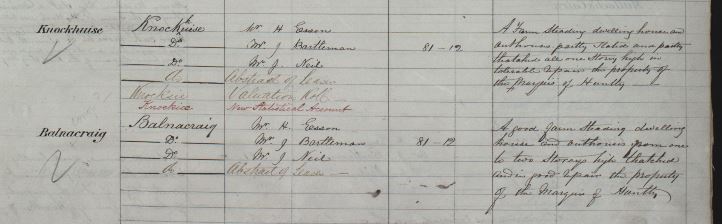
1876 approximately the OS name book entries for
The Ordnance Survey created the OS names book, gathering data from local people to do so. Henry Esson, (b. Balnacraig around 6/9/1821 was noted as advising on names around Balnacraig.
 |
1880’s to around 1918
Kieselguhr
On Dinnet Moor overlain by peat are rich layers of a crumbly sedimentary rock called white clay, diatomaceous earth or kieselguhr as it is known in its processed form. This extremely absorbent and mildly abrasive material is made up from the skeletons of minute algae laid down some millions of years ago. The material has been put to many uses, from storing foodstuffs to a mild abrasive in polish and toothpaste. In 1867 though Alfred Noble discovered that the processed material could absorb up to 4 times its own weight in nitroglycerine. Doing this produced dynamite, a far more stable and so much more useful explosive than nitroglycerine. It was for this purpose that kieselguhr was dug from Black Moss and nearby places from the 1880’s up until the end of the first world war (archival photographs from 1917 suggest that). Up to 50 men were employed, and around 200 tons are said to have been taken from both Black Moss and Ordie Moss in 1885. Runed buildings associated with the works can still be seen, marked on the OS map as “kiesleghur” on the track beyond Monandavan cottage. The material was dried and sent mostly to the Ardeer explosive works in Ayrshire, where organic matter was burnt off in kilns, to form a sixth the weight of useful kieselguhr. This in turn was used to produce dynamite. It is also said to have been used at times to line trenches during World War I. The pictures at the link below show the operation in 1917, and there are many more pictures on the internet.
http://britgeoheritage.blogspot.co.uk/2014/03/black-moss-dinnet-aberdeenshire.html
1890’s
In 1898 Margaret Isabella Low married William Esson, joining the Esson family. It seems she had 14 brothers and sisters. Of those 2 died in infancy, 3 stayed locally, 3 went elsewhere in Scotland, 1 died at 47 from TB, 2 went to Canada, 2 went to New Zealand and 1 went to America. It’s been said by some in the family that of those who went abroad all did well, apart from one who had a bad time harvesting as a farmer with very bad snow and rust disease of their crops.