Bridges And Crossings of the River Tay at Dunkeld
James Ayson was apprenticed to work as a mason on the building of a bridge at Dunkeld in 1511…..
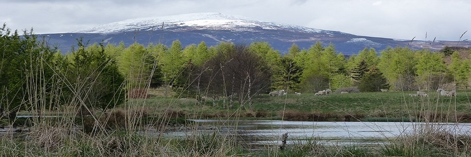
The Tay is the longest river in Scotland. Its waters run 120 miles from Ben Lui in the south west Highlands to the Firth of Tay in the east. The river has a catchment area of 2000 square miles, the largest of any Scottish river. In its lower reaches it traverses Perthshire, West to East, and so has been a significant barrier to travel throughout history, influencing Scotland’s trade, culture and often enough military and political situations.
A natural highway runs from north to south, skirting the highlands and crossing the Tay at Dunkeld. The crossing is trivial now thanks to Telford’s bridge in the town and the A9’s Jubilees Bridge a short way upstream. But the river can rise seventeen feet here in a short space of time and getting over the river could be difficult and even deadly in times gone by. Despite the difficulties, people, livestock and armies passed this way for centuries, millennia in fact, and there is a long history of fords, ferries and bridges designed to make the journey easier. These are noted below chronologically.
The first bridge we can be sure existed was in 1260. Before that it’s quite possible that wooden bridges of some kind were built at times, but we have no reliable accounts. Early bridges are mentioned in two different accounts at least, the first around 80 AD and the second in 830 AD. More to mention the stories and some interesting background than to suggest the accounts are too reliable, they are mentioned first below.
Around 83 to 87 AD, Roman Times

Site of Inchtuthill Roman Fort (indicated by pointer) and the River Tay today : An OS map ca.1850 shows the river took a different route in times past, right next to fortifications on the southern east side and closer to the western side too. Google maps and nls.org
In his book of 1527, Historia Gentis Scotorum (History of the Scottish People) [1] Hector Boece [2] said Julius Agricola built a bridge over the Tay along with a fort to protect it at Inchtuthil, orTulina as he called it. This is a place about seven miles east of Dunkeld. After a time the Romans abandoned the fort, crossed the bridge and destroyed both, before fleeing southwards to escape a hostile Caledonian army. When the pursuers found the bridge destroyed they went to Dunkeld where they quickly built a new one over a narrow part of the Tay. Boece then described how the Caledonians caught and destroyed the fleeing Roman army [3]. That at least was Boece’s story.
How much we believe of this account is up to us. There is no doubt Boece embellished things in general, and he has received much criticism from established historians over the centuries. He has also found defenders more recently however [4], and the main elements of this small part of Historia seem to match quite well with what we know, although we have no way to confirm the existence of the bridges.
The Romans were perfectly capable of building bridges like this very quickly. Julius Caesar himself built a bigger bridge over the Rhine over 100 years earlier in 55 BC [5], between 140 and 400 m long, 7 to 9 metres wide, and crossed a river up to 9.1 m deep. It was built in just 10 days, and he destroyed it after only 18 days when he realised it was expedient to turn back. Granted Caesar had 40,000 soldiers with him, but the scale of the challenge on the Tay would have been smaller.
There are other examples of major forts like Inchtuthil in Britain, next to and defending a bridge but still on the navigable part of a river. Examples include London, York, Chester, Bertha is possibly another, a site ten miles downstream from Inchtuthil at the confluence of the River Almond and the Tay where remains of a bridge have often been declared Roman.

Roman fortifications. The Gask Ridge frontier system showing Inchtuthil’s strategic position.
Inchtuthil fort [6] itself shows the scale of Roman capabilities and resolve here. The fort was built around 83 AD on a raised platform of 49 acres of land on the North bank of the Tay. It was surrounded by a defensive valium and a wall of earth, turf and stone with defensive towers at strategic points and outlying fortifications. There was a quarry at Gourdie which was heavily used, although most of the buildings were of wattle and daub on a timber frame. It is believed the walls of all the buildings combined added up to around 7 miles in length, and the whole construction would have taken thousands of trees.
At some time around 87 AD Inchtuthill was abandoned after being demolished to deny their enemies its privileges. A cache of 875,000 nails of all sizes along with other iron objects such as cartwheels were excavated in the 1950’s from their hiding place in a six foot deep pit.
As one of the few major legionary forts in Britain Inchtutil would have housed about 11,000 men, including 5400 Roman soldiers and a similar number in auxiliaries. It lay at the centre of a broad chain of fortifications, the Gask Ridge frontier system. This ran south west to north east, with Inchtutil at a central point and seems designed potentially to safeguard important routes north as well as protecting the fertile lowlands and access routes from the sea to the east. Inchtuthill would have been able to act as a base for further incursion or to deploy forces rapidly in all directions for defence. A bridge over the river would have facilitated any urgent moves southwards.
There seems little doubt the Roman army would have depended quite heavily on rapidly deployed bridges when they travelled through hostile country. Without them, their advances could be held back, they could have been pinned down or even cut off from support and escape.
All this said, and having considered it carefully we have nothing to confirm the story of bridges here in Roman times.
830
In the New Statistical Account of Scotland for Dunkeld of 1845 [7], the Reverend John Mackenzie mentioned a wooden bridge over the Tay at Dunkeld in 830 AD. He gives no idea of his source however and without corroboration the suggestion is no more plausible than Boece’s account of a bridge almost 8 centuries before.
Perhaps Mackenzie was referring to an account of the somewhat uncertain story of a Pictish King of the Picts who raised a great army and crossed the Tay at Dunkeld northwards and overcame Alpin King of the Scots at Pitalpin around 830-836AD.
1260
At last we have firm evidence from this time onwards. In 1260 A.D. Richard Inverkeithing, Bishop of Dunkeld mentioned a bridge in a letter [8]. He was recording a decision on the fate of Kinkleven, (now Kinclaven) Church. His ruling was that the church’s properties would be divided between Dunkeld church and Cambuskenneth Abbey. Dunkeld would take the church itself, its lands and belongings, and would pay Cambuskenneth 6 merks in annual compensation. He went on to say that if payment of the 6 merks was not made on time, the Bishop of Dunkeld would have to pay half a merk for every 15 days delay for the “fabric of the bridge at Dunkeld” by way of a fine. Perhaps that referred to maintenance of an existing bridge, or the building of a new bridge, given that it was in 1260 that work first started on Dunkeld Cathedral.
1461
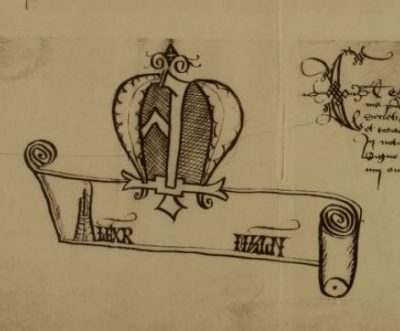
Alexander Myln 1457-1548? His name from a document of 1500
We owe a great deal to Alexander Myln for records he left which give a very clear and reliable understanding of mediaeval Dunkeld. Myln was one of a line of master masons. He supervised work on the building of a bridge at Dunkeld from 1510, and became Master Mason to James V in 1517, around the time the bridge would have been completed.
In Lives of the Bishops of Dunkeld [9] Myln described an attempt by Bishop Thomas Lauder to build a stone and wood bridge in 1461. Lauder did not live to see this bridge finished, and it seems unlikely his successor Bishop Livingstone nor any one else following completed did either.
1510 : “A great and notable bridge made of cut stone on which horse and carriages etc. were able to cross”
In 1510, as mentioned above, Myln was made master of the monks tasked with building a new bridge by Bishop Brown. Myln’s book Rentale Dunkeldensis 1505-1517 [9] consisted mainly of detailed records of the business and accounts of the Cathedral of this time. Much of the focus was on the building the bridge which led to what was likely the first wholly stone bridge at Dunkeld. It seems to have been a project which bears comparison with Telford’s later construction. Records covering single years indicate payments for 932 cart loads of clay, 2500 loads of wall stones and 736 loads of fail (turf) for example.
Piles were driven for the foundations of the bridge, but rafts of wood, turf and stone were also used on gravel and soft ground. Logs were sawn to make boards. Records then tell of carpenters working for weeks at a time to use the planks to make bulwarks to keep water away from the foundations of the bridge piers. Another refers to a smith making 381 nails from re-used iron for the purpose. Turf and heather were also used and ox-hide leather, made supple and waterproof by treatment with bark was used to cover the bulwarks. Wooden frames noted as “basteirs” were also used in construction too. These would have been filled with stones and sunk.
Some stone was taken from the foundations of Lauder’s earlier bridge, but the bulk was quarried on the south side of the Tay at Burnbane quarry near Murthly. This must have been much the same place as Gellyburn, or very close by, where stone was taken for the earlier Cathedral, the 1461 bridge and likely for Telford’s bridge much later. Sandstone outcrops here are surrounded by hard volcanic whinstone, and signs of the ancient quarries can be seen on maps. Quarriers and stone cutters produced the squared stone which a boat carried across the Tay to the North bank at Capoth. There it was loaded onto carts and taken to Dunkeld.
A stable was built at Capoth to house 9 horses used for hauling the stone. Bitumen and animal fat were used to stop the axles of carts overheating and to treat sores the horses suffered from.
Lime was needed for mortar. One source at least were oyster shells, roasted in kilns at “Crawmond”. Cramond as it is today, near Edinburgh, on the South side of the Forth. This was brought by boat to a lime-house at Perth, and from there by cart to the bridge. All this had to be paid for.
Tradesmen listed included smiths, carpenters, sawyers, tanners and so on. Many of these men were recorded with surnames matching their occupation. Payment to workers was very commonly in meal, measured by the boll and firlot. Less commonly money was given, some of that being described as “drink-silver”, literally money for drink. In other cases payment was given in the form of raw materials for the trade of the person involved, amounts of old iron to smiths for example. There are references to clothing and training too, and one record mentions a workman being recompensed for a stolen axe. Another payment was made when a flood at the quarry damaged someone’s fishery, no doubt threatening their livelihood.
James Ayson was recorded as an apprentice baker in 1510 earning 30 shillings (old Scots money) a year. From 1511 until 1518 he was an apprentice mason working on the bridge. For this a series of records over the years noted allowances and payments he received, such as 20 shillings a year for clothing and training, 30 to 50 shillings a year in wages and various large volumes of meal, a firlot a week, 19 bolls for 6 months etc.. These volumes seem far too much for himself, so perhaps he sold the meal or baked bread and sold that.
At the same time the bridge was being built, a ford was maintained, presumably when the river was low enough. There was mention of loads of turf being brought to repair it, and boys were paid 4 s 2d to watch for rising water levels at the ford, on one occasion at least. No ferry was ever mentioned at Dunkeld itself, and the only references to boats seemed to be for workmen or for those carrying goods.
Bishop Brown became increasingly ill until the last year of his life in 1513 when he spent much time watching progress on the bridge from the Bishop’s Palace. He saw the first arch completed, but it was left to his executors and then Bishop Gavin Douglas to complete the work around 1517.
This bridge had just three arches which must have made them quite a size given Telford’s bridge of 1809 included seven. Some accounts suggest the bridge was only open to pedestrians, but Myln was very clear when he described the finished work as “Pons magnus et notabilis ex lapidibus sectis et quadratis edificatus super quo quadrige currus equi etc. transire potuerunt” that is “A great and notable bridge made of cut stone on which horse and carriages etc. were able to cross”.
After its completion, the bridge appears to have been damaged by flood waters, as Archbishop Andrew Dunbar allocated funds for its repair in 1518. Much later in 1561, a provision of 300 merks was made for maintenance.
We do not know how long the bridge was in use for. Most writers seem to suggest the bridge was destroyed in floods around the early 17th century, without giving much evidence.

Part of Timothy Pont;s map Strath Tay Dunkeld to Benchil ca. 1583 to 1596 Strath Tay Dunkeld to
A map produced by Christopher Pont between 1583 and 1596 (to the right) appears to show the bridge intact. According to the National Library for Scotland, some of Pont’s original faded handwriting was later over-written in darker ink by Robert Gordon. It appears just possible Gordon may have overwritten the representation of the bridge in this way, as it appears quite dark. If that is so, it could have been in place as late as 1636, around the time Gordon started producing his own maps. Certainly it does not seem to appear on John Adair’s map of 1683 or the much later Roy map.
Perhaps we might very optimistically guess the bridge survived until the great flood recorded in 1648 which we know destroyed the bridge at Perth.
1693
We can be quite sure there was no bridge at Dunkeld in 1693, as we have an etching by John Slezer of that time to inform us. It also seems unlikely, to me at least, that the bridge was there in 1689 either, as it would surely have been mentioned in descriptions of the battle of Dunkeld in that year.
1724
In 1724 the government of George I sent General George Wade to inspect Scotland to determine what work would help to control the country. On 10th May 1725 he was appointed Commander in Chief of His Majesty’s forces, castles, forts and barracks in North Britain, tasked with carrying out his own recommendations.[10]
Wade chose Dunkeld as the starting point for a military road, heading North to Inverness . There was already a good road from Perth to Dunkeld and he planned to replace the two existing ferries at Dunkeld with a bridge. The story goes, however, that when he asked to meet the first Duke of Atholl at the site in 1724 to discuss the bridge, he was turned down. The Duke replied to the effect that Generals had to come to see Dukes, not vice versa. Neither the Duke nor Wade would compromise so the idea of a bridge here at this time came to nothing.
Maybe the stand-off between the two men was more than just a matter of ego. The first Duke of Atholl was in the last year of his life, and a great deal of politics swirled around these parts at this time. Atholl had sided with the crown in the rebellion only 9 years before, but two of his sons and no doubt others of his acquaintance had taken the Jacobite side. Perhaps the idea of a bridge was not too popular just at that moment, and if Wade was looking for funding, that could have been another issue.
Wade instead built a highly regarded bridge at Aberfeldy, on a second road which ran from Crieff to Dulnacardoch, where it joined his Dunkeld to Inverness road.
1740
From the time the 1517 bridge was destroyed, most likely in the early 1600’s up until 1808, there was no bridge at Dunkeld and people used two ferries, and when possible a ford, practically at the mouth of the RIver Braan where it joined the Tay.
Up river from Dunkeld, to the West, the Inver Ferry was probably the safer of the two ferry crossings, but it could only be reached from the south by another ferry over the River Braan, In 1740 a bridge was built to replace the ferry over the Braan, which must have at least improved this route.
1766
Down river from Dunkeld was the East Ferry. In 1766 a notorious accident here showed how dangerous the Tay could be. Thomas Bisset a manager on the Duke of Atholl’s estate described a fatal accident which occurred in a letter of 3rd November 1766 to the 4th Duke [11].
The river must have been in spate and Bisset explained the ferry had been carrying 13 people and four horses, when an oar broke. The boat was washed over a newly built croy or pier. The fall was substantial and the boat filled with water. The horses panicked and jumped out, adding to the chaos. Four people survived by holding on to the horses. Three others were washed down river holding onto the capsised ferry. Two of those were rescued at Newtyle about 1.5 miles downstream, and the third at Boat of Murthly, just under 3 miles away. Six people were drowned.
1784 and 1791
The 4th Duke of Atholl is said to have become interested in building a bridge at Dunkeld at this time. A design, produced by “an engineer of talents and experience” was mentioned in the Old Statistical Account of 1791. The proposal was for a bridge of three arches, to be built opposite the church of Little Dunkeld, at an estimated cost of £12000.
The account also mentioned Bishop Lauder’s attempt to build a bridge in 1461, and the fact the northern arch and some foundations of Gavin Douglas’ bridge were still visible at times. The loss of Douglas’s later bridge was lamented, pointing out the difficulties and dangers of crossing by ferry.
1802
In 1802 Thomas Telford [12] [13] was commissioned by the British government to survey the state of roads in the highlands . Following this he was appointed surveyor and engineer of the new Commission for Roads and Bridges in the Highlands of Scotland to implement his recommendations. An Act of Parliament established the Commission and indicated the government would fund around half the costs of major works, while local landowners would provide the rest. The approach was met with enthusiastic support from dignitaries across Scotland. This, coupled with Telford’s capabilities and energy as a leader meant the Commission was very successful. By 1821 it was able to report 120 new bridges and 950 miles of new roads had been constructed in the highlands. This work, especially the bridges must have transformed communications and trade throughout the area. This point was commented on by a retired and renowned circuit judge in the 1880’s whose career had included the difficulties of travelling before the advent of many bridges and the railways.
1805-1809
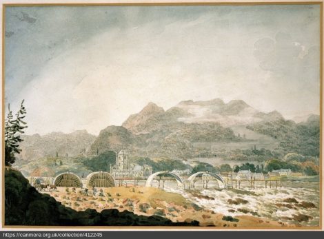
George Heriot, 1766-1844. Titled: ‘The Building of Telford’s Bridge at Dunkeld, Perthshire’canmore.org.uk
In 1805 Telford started work on his Dunkeld Bridge with a design very different to Myln’s bridge and to the one described in the Old Statistical Account. His bridge had seven arches, and a relatively flat upper profile in the form of the arc of a great circle. Rather than completely fill the core of the bridge with loose stones as was common practice before this time, Telford instead built internal longtitudinal walls inside the structure to form sealed voids. This allowed a stronger bridge to be built using less material. This was an innovation which the famous bridge builder John Smeaton had used earlier in 1771 when he built his bridge at Perth.
Telford decided to build his bridge just upstream of the East Ferry where he said a ford at the mouth of the River Braan broke up the ice in winter.
The bridge piers, the base of the arches, were built on dry ground. It has often been suggested this was achieved by Telford diverting the river one way and then the other, and it may be that he used some means such as cotterdams to help with this.
However, in an account of a tour of Scotland which Robert Southey took with Telford in 1819 [14], Southey stated that Telford had been lucky enough to have the river naturally diverted by a huge deposit of gravel from the River Braan’s mouth. This he said had allowed Telford to build half of the six bridges piers on dry land to start with, and then by clearing the gravel and letting the river return to its normal course he was able to complete the remaining piers, again on dry land. Southey’s account seems likely to have at least some truth in it as he would have heard this from Telford himself. The two seemed as if they were in tune as while Southey praised Telford’s bridge, he was very scathing about Wade’s Aberfeldy bridge, for no very obvious reason.
A map of 1823 gives some interesting clues as to the way the river was diverted either in Telford’s time, or at an earlier date. Given the apparent age of buildings on reclaimed land maybe the diversion predated Telford by some way. The area just downstream of the bridge shown as water on this map has been reclaimed too now.
A number of seemingly reliable accounts suggest the bridge was opened on the 7th November 1808. Others say it was opened on 29th March 1809. Perhaps an official opening was delayed, maybe for some work to be completed, perhaps for the toll house on the South side of the river to be completed. On opening the bridge, Dunkeld’s two ferries were closed and Alexander Ferguson, the renowned oarsman who operated East ferry at Dunkeld went as an assistant and eventual successor to “Boaty” Proudfoot at Caputh Ferry, a few miles downstream from Dunkeld. [15]
Almost from the outset the finances of the bridge were controversial and figures of all kinds seem to have been quoted by different parties.
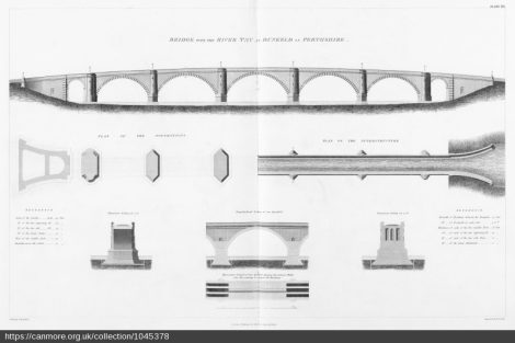
Telford’s Design
The initial estimate of £12,000 for the bridge was coincidentally the same quoted for the very different bridge mentioned in the Old Statistical Account. Telford’s estimate was £15,000 with the suggestion the Duke of Atholl and the government would split the cost. The Parliamentary Act for the bridge passed in 1803 ruled that Atholl would have £25000 in total for the bridge, £7000 from the government and £18000 which he would pay and replace with pontage charges for the bridge. The final cost though was closer to £40,000.
The bridge was no doubt appreciated by the public but the tolls came to be strongly resented, particularly when people had to pay just to get to and from the Free church and the new railway station on the South side of the river. [16].
When the bridge opened it charged a bawbee per head for transit. By 1853 it was believed by the public the debt should have been paid, and the Post Office made repeated efforts to address the costs. In 1867 the Free Church also raised understandable objections on behalf of parishioners being charged twice on Sundays, and maybe when these were not heeded it was the last straw.
The next year in 1868 things came to a head and rioting began. The wooden gate on the south side of the bridge was taken off and thrown in the river, where it floated down to Caputh. A second one was hacked to bits and auctioned, and a meeting of 4000 people gathered under the Birnam tree to discuss the problems.
The chronicles of the Atholl family recorded “This year an agitation was commenced regarding Dunkeld Bridge, the public alleging that the Duke’s powers to levy
pontage had expired. Much ill-feeling arose ; some took his Grace’s part, and some the reverse. Disturbances took place, litigation followed, and eventually the wooden gates were torn down and thrown into the Tay. This outrage caused the Sheriff-Substitute to swear in sixty special constables at Dunkeld to keep the peace, and soon after it was found necessary to station in the town a detachment of twenty-five men of the 42nd High-landers, under the command of Captain Farquharson. The presence of the military quieted matters, and the gates were soon replaced by others of iron“. The replacement gates were incidentally renowned for their ornamentation.
A court action was taken out against Atholl in 1869 by Alexander Robertson. also known as Dundonachie, a successful merchant who was prone to taking on the aristocracy [17].
Atholl defended himself claiming he had the right to reclaim the full costs via pontage charges. By this time the debt was said to have grown to £58,000. Matters were made worse by the new Highland Railway to Inverness which reduced traffic over the bridge to next to nothing. In the end Atholl was given leave to continue charging, but only to cover £18,000.
A charge of sedition was brought against one of the protesters, quite possibly Dundonachie, for producing pamphlets to protest at the bridge. Whether it was during this case or not. Dundonachie was given a short prison sentence for “murmuring against a judge”.
Even now, things did not settle down completely. The original Ossian’s hall folly on the Atholl estate was blown up in protest, much to the disgust of the Manchester Courier and Lancashire General Advertiser which reported on 8th September 1869 “Diabolical Affair at Dunkeld. Ossian’s Hall at the Hermitage near Dunkeld blown up by gunpowder”. The culprits. though suspected were never charged.
A small cell had been built into the bridge stone work beneath the Northern arch mimicking a similar one under the 1517 bridge. There is not much evidence of this being used, but perhaps it came in useful at times for rioters. The extraordinary and protracted conflict of this time perhaps reflected a growing general dislike of perceived unfairness in Scotland. There was some talk the Duke of Atholl would have built the bridge for his own purposes anyway, even without the subsidies.
Tolls were eventually ended when the bridge was taken into public ownership in 1879. The bridge continues in good form today, supporting colossally greater loads than Telford could ever have imagined.
1845 New Statistical Account for Dunkeld

Dunkeld Bridge today from engineeringtimelines.com
Despite the troubles, the benefits of the bridge did not go unnoticed. The Reverend John Mackenzie praised its effect in the New Statistical Analysis for Dunkeld [7] saying:-
“Before 1809, the traffic was mostly all conducted on horseback. There was a post runner to Dunkeld, but there was no post beyond it, except his Grace’s runner to Blair. Now, there are nearly twenty carriers that pass Dunkeld weekly to the Highland districts. There is the daily mail to Inverness through Atholl, and a stage-coach to Perth thrice a week. In the summer months, there are daily stage-coaches from Dunkeld to Inverness, Dundee, Lochlomond, Perth, &c”
1977
Coming up to much more modern times, the Jubilee bridge was opened over the Tay to carry traffic on the A9 in May 1977 just to the north west of Dunkeld. The Tay Crossing as it is commonly known, replaced Telford’s bridge as the main through route. It has a concrete deck, carried by three spans of steel girders supported on two pairs of piers set at the edge of the river. At the southern end of the bridge, a concrete box bridge carries the A9 over the railway line. [18]
References – links read at 16-8-2019
1. Hector Boethius, Scotorum Historia (1575 version) Book 4. This link is to an extended 1575 version of the 4th book translated in modern times and posted online by Dana F. Sutton of the University of California, in February 26, 2010. http://www.philological.bham.ac.uk/boece/4lat.html
2 Entry for Hector Boece on Wikipaedia : https://en.wikipedia.org/wiki/Hector_Boece
3.
4. Hector Boethius, Scotorum Historia (1575 version) Book 4. This link is to a 1575 version translated in modern times and posted online by Dana F. Sutton of the University of California, in February 26, 2010. http://www.philological.bham.ac.uk/boece/intro.html
5. Caesar’s Bridges over the Rhine – Wikipaedia : https://en.wikipedia.org/wiki/Caesar%27s_Rhine_bridges
6. Inchtuthil Roman fort : Wikipedia https://en.wikipedia.org/wiki/Inchtuthil
7. New Statistical account for Perthshire, including Dunkeld https://www.electricscotland.com/history/statistical/The_New_Statistical_Account_of_Scotland_10.pdf
8. Registrum Monasterii S. Marie de Cambuskenneth, A.D. 1147-1535 By Grampian Club (London); Fraser, William, Sir, 1816-1898 https://archive.org/details/registrummonaste00gram/page/386
9. Lives of the Bishops of Dunkeld (1488-1517) and Rentale Dunkeldensis (1505-1517) https://archive.org/details/rentaledunkelden00cath/page/n12
10. General George Wade on Wikipaedia https://en.wikipedia.org/wiki/George_Wade
11. Chronicles of the Atholl and Tullibardine Families Volume IV p. 23 : John, Seventh Duke of Atholl K.T. https://archive.org/stream/chroniclesofatv41908atho/chroniclesofatv41908atho_djvu.txt
12. The life of Thomas Telford by himself 1838 p. 291 Link to book in pdf
13. Thomas Telford on Wikipaedia https://en.wikipedia.org/wiki/Thomas_Telford
14. Journal of a tour in Scotland in 1819 by Robert Southey 1819 https://archive.org/stream/journaloftourins00sout/journaloftourins00sout_djvu.txt
15. From a booklet setting out the history of The Boat of Caputh by Sir Alexander Muir Mackenzie
16. Chronicles of the Atholl and Tullibardine Families Volume IV -.p. 482: John, Seventh Duke of Atholl K.T. https://archive.org/stream/chroniclesofatv41908atho/chroniclesofatv41908atho_djvu.txt
17. Dundonachie : A description of his action in the Dunkeld Bridge protests by Henry Dryerre III (https://www.electricscotland.com/poetry/dryerre) (on electric Scotland https://www.electricscotland.com/poetry/dryerre/Worthies41DunkeldBridgeQuestion.pdf
18. Jubilee Bridge carrying the A9 Dunkeld bypass from 1977 : Readers Digest : Sabre Roads : https://www.sabre-roads.org.uk/wiki/index.php?title=Tay_Bridge_(Perthshire)
Thanks to
David Simpson of roysroads.co.uk
Canmore canmore.org
National Library of Scotland www.nls.uk
https://scotlandsoldestbridges.co.uk
and many more